
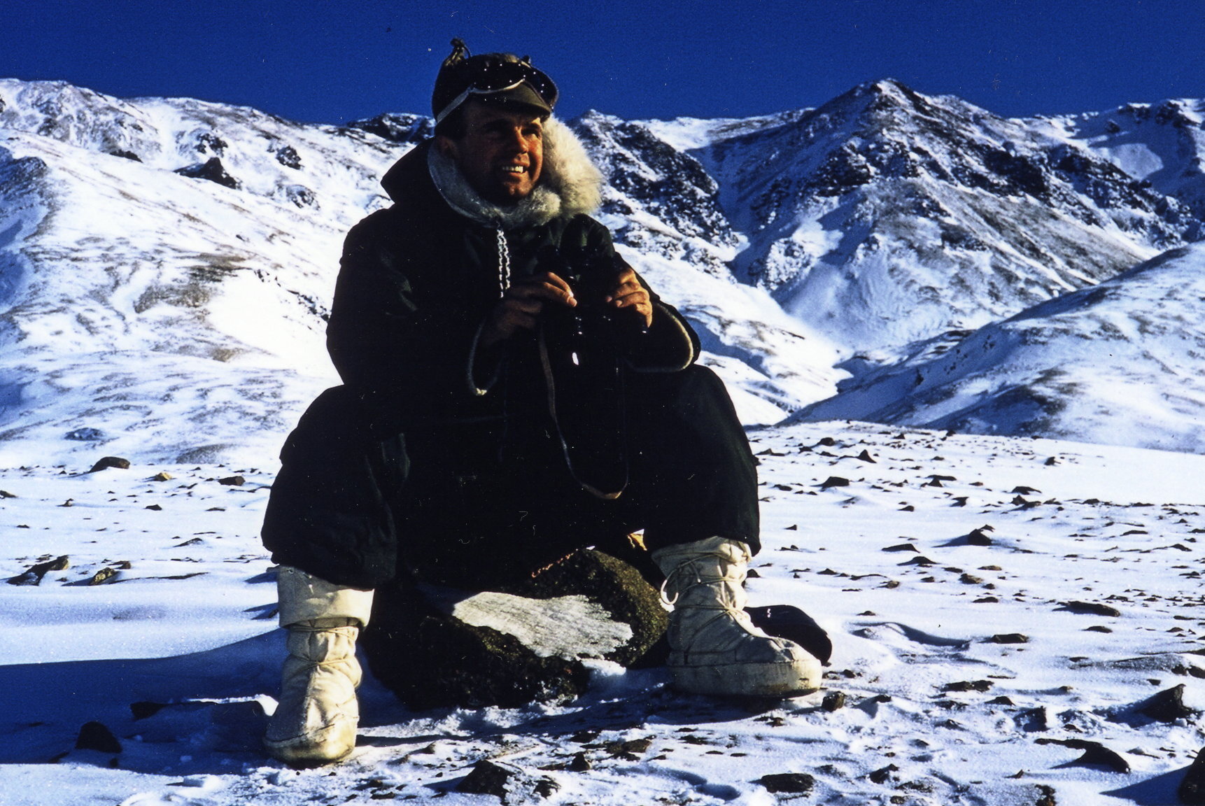
Dr. Raymond Thorsteinsson PHD

(1921 - 2012)
Geologist/Mapped Arctic
Wynyard, SK, Calgary, AB
No name is more inextricably linked with the geology of the Canadian Arctic Archipelago than that of Ray Thorsteinsson. His death in Calgary on 23 April 2012 at the age of 91 brought to a close a career spanning 62 years, including 39 field seasons, devoted to the exploration and study of the Arctic Islandsundefineda record of achievement unlikely ever to be duplicated.
Raymond Thorsteinsson was born in Saskatoon on 21 January 1921, the second of five children born to his Icelandic-Canadian father, Peter Thorsteinsson, and English-Scottish mother, Elizabeth (nee Readman). In 1905, the Thorsteinsson family established a homestead overlooking Big Quill Lake in the town of Wynyard, Saskatchewan, and some of that original homestead still bears the Thorsteinsson name. Ray was proud of his Icelandic heritage and learned to speak the language as a child in order to communicate with his unilingual Icelandic grandparents.
Already as a boy, when he milked cows and worked in the grain fields on the family farm during the "Dust Bowl" and Depression in the 1930s, Ray found hard work to be rewarding. In his spare time, he would go on long hikes, observing the abundant diversity of wildlife in the area and hunting for arrowheads and other Native artifacts, activities that inspired a lifelong interest in exploration and particularly in paleontology.
Throughout his life, Ray maintained ties to his home farm in Wynyard, visiting regularly to help his close-knit family with farm work and to hunt geese and ducks. Ray was always fascinated by astronomy, and at the farm, where the night sky always seemed brighter than in the city, he enjoyed identifying specific stars and constellations for his young children Ray's sister Thora, who often accompanied Ray and his family on the drive from Calgary to Wynyard, recalls that Ray loved to listen to classical music during the trip. Ray also enjoyed playing the mouth-organ on the farm; his rendition of Freight Train was always a special treat for Thora.
In 1944, Ray was awarded a BA degree in geology by the University of Saskatchewan, where he was recognized as a skilled boxer as well as a promising student. In late December 1944, Ray married Jean Kristjansson, of Leslie, Saskatchewan, who bore him Erik in 1945 and Anna Ingrid in 1961. "Jeannie" was the anchor in Ray's life, providing him with inspiration and the domestic stability that enabled him to spend long seasons in the field and long days in the office up until her death in 1998
From the time of his graduation in 1944 until he completed his master's degree in Toronto in 1949, Ray worked on Geological Survey of Canada (GSC) field parties. He worked first as an assistant to Dr. Stan Duffell in the Ash-croft-Lillooet area of southern British Columbia in 1945 and 1946 and to Dr. R.J.W. (Bob) Douglas in the Living-stone Range of southwestern Alberta in 1947, then as party chief in the Grande Cache area of west-central Alberta in 1948 and 1949. While working in the field with Douglas, Ray mentioned that he had read a number of books on the Arctic by the great Icelandic-Canadian explorer Vilhjalmur Stefansson and that he would also like to work in the Arctic some day. Douglas promised to pass that information on to the Director of the GSC in Ottawa.
In 1949, when Ray was finishing his MA degree in paleontology at the University of Toronto and preparing to begin PhD studies at the University of Kansas, E.T. (Tim) Tozer arrived in Toronto to complete his own graduate studies in paleontology. They became close friends, and in 1952 both joined the permanent staff of the GSC, where they forged a scientific partnership that significantly advanced knowledge of Arctic Islands geology.
Ray began his PhD studies in Kansas under the direction of the renowned stratigrapher-paleonlologist R.C. Moore in 1949. Shortly thereafter, Dr. Yves Fortier, who at the time led the GSC's activities in the Arctic Islands, invited Ray to join him in the initial geological reconnaissance of Corn-wallis and Little Cornwallis Islands in 1950. Ray accepted the invitation with alacrity.
When asked about the circumstances that led to his involvement with the Arctic Islands, Ray was always quick to credit his colleagues Bob Douglas and Yves Fortier for "that particular stroke of luck." He would add that Winston Churchill also played a role in his career path. In his famous "Iron Curtain speech" in the United States in March 1946, Churchill announced that the "Cold War" had already begun and that he was worried by Stalin's ambitions along the Soviet Union's Arctic frontier. America became alarmed by the possibility of Soviet incursions into the North American Arctic. Within a few months of Churchill's speech, an American icebreaker and several supply ships sailed to Melville Island to select sites suitable for the construction of a network of joint Canada-U.S. weather stations in the Canadian Arctic Islands. The purpose, of course, was not only to record meteorological data, but also to keep watch on the Soviet military. By 1950, weather stations were operational at Mould Bay (Prince Patrick Island), Isach-sen (Ellef Ringnes Island), Resolute (Cornwallis Island), and Eureka and Alert (Ellesmere Island). The presence of this network of stations with airstrips and communications facilities gave impetus to the Geological Survey to initiate a new, modern era of research and mapping in the Arctic Islands.
The 1950 field party consisted of Fortier, Ray, and Trevor Harwood, an engineer with the Defence Research Board and an old Arctic hand who had previously worked for the Hudson's Bay Company. Fortier's plan was to circumnavigate Cornwallis Island in a 7 m freighter canoe powered by a 5 hp outboard motor. The party flew to Resolute Bay from Edmonton in early June in a Royal Canadian Air Force Lancaster bomber, with the canoe in the bomb bay. It was Ray's first flight in an airplane, and a cold one at that: the large canoe prevented the bomb bay doors from closing properly, and the temperature in the hold was well below zero. Upon arrival in Resolute, Yves, Ray, and Trevor discovered that the sea ice was completely locked against all shores of Cornwallis Island, rendering travel by canoe impossible, so they conducted traverses on foot around Resolute Bay to gain at least a preliminary impression of the geology.
While waiting for the sea ice to disappear, Ray and Yves were invited by J Glen Dyer, chief of the Arctic and Antarctic weather stations for the U.S. Weather Bureau, to accompany him on a mail run to the new weather stations at Mould Bay and Isachsen in a United States Air Force DC-4. Visibility was unlimited and the pilots flew their aircraft as high or as low as Ray and Yves asked and even circled in places for a better view of the geology. Not long after, Ray and Yves rode along on another mail run, this time to Eureka.
By mid-July, sea ice conditions had improved, and on 21 July, their freighter canoe laden with some 4000 pounds of fuel, provisions, and equipment, Ray, Yves, and Trevor departed Resolute Bay, heading east After numerous weather- and ice-related delays, encounters with polar bears and walruses, and other adventures, the trio arrived back in Resolute on 22 August, completing the circumnavigation of Cornwallis Island without the aid of modern maps, only old British Admiralty charts. The geological structure and stratigraphy of the island having proved much more complex than he had anticipated, Fortier turned the project over to Ray to complete the mapping and use the results for his PhD dissertation.
Ray was back on Cornwallis Island next year, again with a canoe, this time powered by a 10 hp motor. Revisiting the south coast, he discovered, in a cairn east of Assistance Bay, a note left by Captain Sir John Ross during the Franklin search in 1851, exactly 100 years earlier. It was the first of many important finds of earlier explorers' records that Ray was to make. After two more field seasons, Ray completed his field studies on Cornwallis and Little Cornwallis Islands in 1953. He submitted his dissertation to the University of Kansas in 1954 and was awarded the PhD degree in 1955.
The reconnaissance flights to the weather stations that Ray and Fortier had undertaken in 1950 proved invaluable for interpreting tectonics and structure across much of the Arctic Archipelago. They had observed the magnificent sequences of folded Paleozoic rocks on Bathurst and Melville Islands (Parry Islands Fold Belt), which were overlain by little-deformed Mesozoic strata on Melville Island. They also saw, on the Ringnes islands and Axel Heiberg Island, numerous piercement structures (salt domes) penetrating the Mesozoic strata. Building on those observations and the published literature, they coauthored an insightful summary paper with A.H. McNair (Fortier et al., 1954) that described for the first time the structural character of the vast territory between northern Greenland and the Beaufort Sea. This paper also contained one of the earliest references to oil and gas prospects in the region.
In 1955, Ray and Tim Tozer participated in Operation Franklin, a large, helicopter-supported GSC survey, led by Fortier, which produced geological maps and reports covering at least 260000 km2 of the High Arctic. On Operation Franklin, responsibility for describing the stratigraphy of the upper Paleozoic (Carboniferous and Permian) and the Mesozoic rested with Ray and Tim, respectively.
The next year, Ray and Tim worked out of Eureka, on western Ellesmere Island. In the spring they used two sledges, 20 dogs and two Inuit dog-drivers to make traverses, for the most part independently, along the coasts of Ellesmere and Axel Heiberg Islands. They collected abundant fusulinaceans and ammonoids, which they identified to establish a biostratigraphic framework for the upper Paleozoic and Mesozoic sequences. Later in the season they worked with canoes and on foot. Ray returned to Eureka in 1957, again working with sledge, canoe and on foot, and traveling as far afield as Meighen Island, where he discovered the westernmost record of the ill-fated 1930 German Arctic Expedition led by H.K.E. Kruger (Thorsteinsson, 1961).
In 1958, Ray and Tim pioneered the use for regional geological mapping of a Piper Super Cub aircraft fitted with large, low-pressure tires that enabled the aircraft to land on unprepared ground Their pilot was the innovative northern aviator Welland W (Weldy) Phipps, who had developed the technique for use in the Canadian High Arctic. In that single summer, they flew a total of 300 hours, making 400 landings with either Ray or Tim aboard, and mapped the western Queen Elizabeth Islands, an area approximately the size of Vancouver Island. In 1959, Ray and Tim were joined by fellow GSC geologists R.L. Christie and J.G. Fyles in mapping the geology of Banks, Victoria, and Stefansson Islands, using two Super Cubs with the Phipps tires.
Ray's encyclopedic knowledge of the history of exploration in the Arctic Islands was gained by close reading of books by, and accounts of, the early explorers. During the 1958 field season, Ray found records and relicts of W.E. Parry (1820) and F.L. M'Clintock (1853) on Melville Island, including M'Clintock's cart that he had abandoned along with scientific specimens and equipment. Particularly memorable for Ray was the finding, in 1958 in the company of Tim, of the record of Stefansson's discovery of Brock Island in 1915. Stefansson had named Brock Island after R.W. Brock, Director of the Geological Survey of Canada, which had provided financial support for Stefansson. In 1959, Ray was invited to lecture at the geology department of Dartmouth College in Hanover, New Hampshire, where Stefansson lived. Ray showed Stefansson his Brock record, 44 years after Stefansson had written it, and was delighted to hear Stefansson say that he thought it particularly fitting that a member of the Geological Survey and fellow Icelandic-Canadian should have headed the second party to visit Brock Island.
By 1960, Ray and Tim Tozer had assembled sufficient structural and stratigraphic data to define the Sverdrup Basin, which extended through the northern islands of the Archipelago and which contained at least 13 km of upper Paleozoic and Mesozoic strata. Between 1961 and 1986, a total of 176 wells were drilled in search of petroleum in the Arctic Islands, mostly in the highly prospective Sverdrup Basin. Unquestionably it was the work of Ray and Tim that laid the foundation for that extraordinary period of exploration.
Ray continued to map the geology and refine the upper Paleozoic stratigraphy of Axel Heiberg and Ellesmere Islands, and in 1974 published a benchmark monograph (Thorsteinsson, 1974), along with 15 new regional geological maps. This work was followed by a memoir with five maps on Devon Island, where the sedimentary succession consists largely of lower to middle Paleozoic rocks (Thorsteinsson and Mayr, 1987),
Although regional mapping took up much of his time, Ray was at heart a biostratigrapher. Paleontology was a special passion, in which he displayed extraordinary versatility. On Cornwallis Island he discovered graptolites, important index fossils for the lower Paleozoic, in an unusually complete state of preservation. His detailed studies of their form and evolution gained him an international reputation. When Ray subsequently worked on the upper Paleozoic strata of the Sverdrup Basin, he turned his attention to the fusulinaceans, a fossil group of particular chronologic significance to those rocks. Following that work, he made a radical switch to vertebrate paleontology in order to concentrate on a fish fauna that he had discovered in Silurian and Devonian rocks on Cornwallis and other Central Arctic islands and of which he had amassed a large collection. These fossils were heterostracans, small, primitive, jawless, armoured fish that occupy a place in the lineage of Man's earliest ancestors. Characterization of these forms requires knowledge of their anatomy and Ray learnt the necessary preparatory techniques during a stay at the Swedish Museum of Natural History in Stockholm in 1965-67. Ray's heterostracan studies were a focus of the later stages of his career and indeed, at the time of his death, he had almost completed a major monograph on this topicundefineda true magnum opus that will be published posthumously.
In 1992, after 40 years of continuous service with the Geological Survey of Canada, Ray retired, but he continued to work as a Research Scientist Emeritus until a few weeks before he died.
The list of honours and awards garnered by Ray for achievements in geology, paleontology, and exploration is long and distinguished: election to the Fellowship of the Royal Society of Canada, 1960; Founder's Medal, Royal Geographical Society, 1969 (jointly with E.T. Tozer); Wil-let G Miller Medal, Royal Society of Canada, 1973; Logan Medal, Geological Association of Canada, 1979; Massey Medal, Royal Canadian Geographical Society, 1981; R J.W. Douglas Medal, Canadian Society of Petroleum Geologists, 1982. In 1983, he was nominated to the Order of Canada as a Member; he was promoted to Officer of the Order in 1989.
Ray was a gracious, self-effacing, innately modest man. His work ethic, both in the field and in the office, was legendary, yet he was easy-going, had a fine sense of humour, and enjoyed a good laugh. In the field, he was a delightful companion and an extraordinary teacher in both geology and paleontology and the history of Arctic exploration. His interests outside work were broad and varied, ranging from history and politics to classical music and poetry. Surely it is Canada's good fortune that a man of the calibre of Raymond Thorsteinsson devoted his life to the task of resolving the geology of her northernmost territory.
Ray is survived by his wife, Phyllis, son Erik (Mary), daughter Anna Dagnall (Jason), and sisters Thora Moir and Thelma Lissel.
REFERENCES
Fortier, Y.O., McNair, A.H., and Thorsteinsson, R. 1954. Geology
and petroleum possibilities in the Canadian Arctic Archipelago.
Bulletin of the American Association of Petroleum Geologists
38:2075-2109.
Thorsteinsson, R. 1961. The history and geology of Meighen
Island, Arctic Archipelago. Geological Survey of Canada
Bulletin 75. 19 p. undefinedundefinedundefinedundefined. 1974. Carboniferous and Permian stratigraphy of Axel
Heiberg Island and western Ellesmere Island, Canadian Arctic
Archipelago. Geological Survey of Canada Bulletin 224. 115 p.
Thorsteinsson, R., and Mayr, U. 1987. The sedimentary rocks of Devon Island, Canadian Arctic Archipelago. Geological Survey of Canada Memoir 411. 183 p.
Walter W. Nassichuk
Geological Survey of Canada
3303-33rd Street NW
Calgary, Alberta T2L 2A7, Canada
Walter.Nassichuk@NRCan-RNCan.gc.ca
and
Thomas Frisch
545 Piccadilly Avenue
Ottawa, Ontario K1Y OH9, Canada
Note:
Raymond was a Charter Member of the Leif Eiriksson Icelandic Club of Calgary.